Difference between revisions of "Geobase"
(→CDED (Canadian Digital Elevation Data)) |
(→Downloading the files) |
||
| Line 19: | Line 19: | ||
Continue to click on the Map until you are fully zoomed in to the area of interest. You will know you are fully zoomed in when you see a listbox at the bottom of the page. Now as you click on the map. The map names will be added to the listbox. When you are ready to download click Submit. | Continue to click on the Map until you are fully zoomed in to the area of interest. You will know you are fully zoomed in when you see a listbox at the bottom of the page. Now as you click on the map. The map names will be added to the listbox. When you are ready to download click Submit. | ||
| + | |||
| + | [[File:CDED-1.jpg|700px]] | ||
Select the html download links for each file and download them all in to a directory. The files are zipped so you should unzip all the files to a main directory. You should now have a folder that contains all the .dem files along with other meta data files that are not important. | Select the html download links for each file and download them all in to a directory. The files are zipped so you should unzip all the files to a main directory. You should now have a folder that contains all the .dem files along with other meta data files that are not important. | ||
Revision as of 15:22, 4 April 2013
Contents |
GEOBASE - Canadian terrain data
Geobase has elevation data (CDED), Vector data for roads etc. and satellite imagery for all of Canada.
Geobase main page: http://www.geobase.ca
CDED (Canadian Digital Elevation Data)
The CDED (Canadian Digital Elevation Data) is available in 1:50,000 and 1:250,000 resolution.
Downloading the files
If you have not already done so, you will need to register an account. Use this page to create an account: http://www.geobase.ca/geobase/en/register.jsp
Files can then be downloaded from: http://www.geobase.ca/geobase/en/data/cded/index.html
Click on the desired resolution data source.
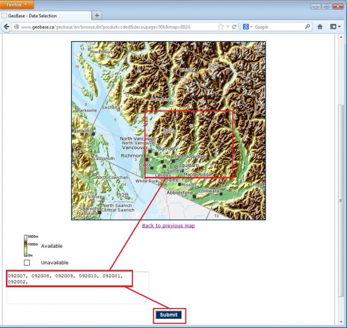
Continue to click on the Map until you are fully zoomed in to the area of interest. You will know you are fully zoomed in when you see a listbox at the bottom of the page. Now as you click on the map. The map names will be added to the listbox. When you are ready to download click Submit.
Select the html download links for each file and download them all in to a directory. The files are zipped so you should unzip all the files to a main directory. You should now have a folder that contains all the .dem files along with other meta data files that are not important.
These must be converted to a binary format in the Pathloss program before they can be used.
Using CDED files with Pathloss 5.0
Start Pathloss 5. Click Configure - Setup GIS Configuration. Select the Primary DEM tab and follow the image below to convert the .dem files to the binary data Pathloss can use. Multi-select all the .dem files. You can safely save them in the same directory (You will be asked for the save location only once.)
Close the index and click OK.
Using CDED files with Pathloss 4.0
- Download and unzip the CDED files to your hard drive.
- In the Pathloss program select Configure-Terrain Database
- Select DTED-CDED indexed files from the Primary list
- Click the Setup Primary button
- Click the Set directory button. Set the directory to where the un-zipped CDED files are located and click OK
- Click the USGS to DTED button. A file selection dialog box will open, select the DEM files that you have downloaded and un-zipped and click Open. The files will be converted, added to the index and are ready to use.
For more information see the manual under CDED-DTED indexed files.
